Despite being a student of geomatics, Pratichhya Sharma from Pokhara never thought how modern computer and mobile technologies embedded ideas of her science so that it could be available to everyone. She, of course, would use maps available on various websites whenever she would visit different places, but apparently had taken them for granted.
It was the story till 2016 March. Now, two years down the line, a student of Pashchimanchal Campus under the Tribhuvan University Institute of Engineering, Sharma is busy for around two hours a day mapping different places of Nepal and the world, that too voluntarily.
This transformation in Sharma’s life perhaps is parallel to how digital mapping evolved in Nepal over these years.
Paradigm shift
Remember a time you had to visit some relative’s place or any office around 10 years ago—you find a landline phone number, call them before you leave your home, ask for directions and exact location, reach somewhere nearby, ask people around, if they cannot give you any hint call your host again, confirm the place and go in.
Now, imagine yourself in the same situation today—you have a map on your mobile phone, you search the place on the map, you find the exact location, the map shows you the direction with estimated time and available modes of transportation, you follow the route, the map pinpoints the location (the exact building) and you go in.
So, what’s the difference? The amounts of time, energy and resources you spend in these two examples are of course very much dissimilar. But, the two situations are basically different in one respect only: your access to digital maps.
People often fail to take notice of it as maps, easily available on multiple websites and mobile phones, are taken for granted. It’s there already when you buy your new phone. Just download the app and you have the map.
However, the task of mapping is way more difficult than searching a particular location on your device. Digital mapping is a very complex process. Millions of people like Sharma are involved in the process.

Youth in mapping
Sharma contributes to the Open Street Map, a digital map operated by the international organisation with the same name. (It is different from Google Maps—the differences will be discussed later.)
Sharma’s contribution to Open Street Map for the coverage of Nepal is second biggest. The top contributor is Shree Krishna Adhikari, Sharma’s junior at the Campus. Since January 25 this year, he has created 2,131 changesets and 630,606 map changes on the Open Street Map (These are technical units used to measure contribution of mappers on the OSM). Besides Nepal, he has also mapped locations of Tanzania, Congo and South Africa among others.
For this 23-year-old youth, who has been migrated to Pokhara from his house in Kavre for the studies, mapping in the traditional paper format would only be a set of technical information difficult to read for laymen. However, digital mapping is a perfect mirror to society, according to him.
Sharma and Adhikari were introduced to mapping by a nonprofit company called Kathmandu Living Labs. The organisation hosts different sorts of training courses at multiple levels and interested youth can continue mapping after the training.
Sharma was a participant of the first edition of Digital Internship and Leadership training in 2016 whereas Adhikari is a member of the second cohort hosted in 2017. According to KLL’s Pradip Khatiwada, total 30 people like the duo are volunteering for mapping Nepal on Open Street Map.
In fact, Khatiwada himself is a live example of new generation’s interest in mapping. An active social campaigner, Khatiwada’s interest in mapping grew up, after observing how security officials used maps in their rescue efforts in the 2015 earthquake and joined the KLL team with a responsibility to coordinate among youth for its training and other events. He is also the fifth biggest contributor to Open Street Map for data of Nepal.
Khatiwada says he was a social science student and knew nothing about maps; highlighting that everyone could be a mapper if they really had a wish.
The other side of globe
Open Street Map is not the single type of digital mapping. More common than the OSM is Google Maps, a service offered by Google.

Differences between the two services are not apparent for users in general except in the design and appearance. However, in a closer look, the major difference is all about wideness vs openness.
Google (.com) is a for-profit private company whereas Open Street Map (.org) is a nonprofit organisation. You cannot easily edit Google Maps though you can suggest changes. Open Street Map is open to read and write—you can not only download and use it, you also can point places you have visited and edit the data which are already there. Google Maps has limited offline use scope whereas you can have a full-fledged access to Open Street Map once you download it on your device.
For users, both have their own pros and cons. Because Google might have mobilised more resources to collect data, its coverage is wider than Open Street Map. The second, however, has data for limited places; but wherever they have data from, they are so detailed, even more detailed than Google. For example, if you check any location of Kathmandu city area on Open Street Map, it shows you exact block number and the name of alley or road.
No data is easily available on who or which companies work to update Google Maps in Nepal. According to Prijun Koirala, a member of Local Guide Nepal, a loose network of people involved in updating Google Maps and other information for Google in Nepal, three are 200 to 300 contributors like him in the country.
“But, you as an individual can also approach Google and get an authority to contribute,” he says, hinting there can be some other individuals who are contributing to Google, but not yet in contact with the network.
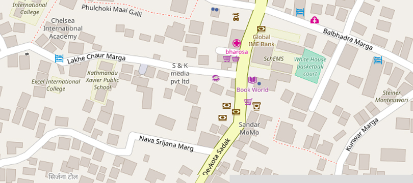
On the other hand, Open Street Map believes in the philosophy that everybody is a mapper, hence exactly figuring out who contributes to it is quite tough.
“Of course, everybody can edit the map,” Nama Raj Budhathoki, Executive Director of the KLL, says “But, we have a global community of around 500,000 persons who constantly monitor the changes made and ensure that the data are truthful.”
Budhathoki’s company is not restricted to mapping only. In fact, the company cannot survive on mapping as it is one of the least lucrative tasks the company does. “However, it is our flagship project and we will continue even if we do not earn a single penny,” he says.
Open data and mapping
Budhathoki is a pioneer of ‘open data movement’ in Nepal. “Open Street Map is one of the most evident and successful examples of global open data system,” he says, “This technology cashes on in the frustration people had with traditional mapping as traditional maps were not much user friendly and they could not have been updated.”
Open Street Map believes in French philosopher and media scholar Pierre Levy’s idea that no one knows everything, but everyone knows something. “For us, everybody is a mapper as they can map their locality better than any scholar from other places,” Budhathoki shares, “Our company is supporting the movement of Open Street Map to integrate local knowledge for benefits of everyone in the world.”

Whereas openness is the unique selling point for Open Street Map, pro-Google people might question the reliability of data for the same reason. It is like Wikipedia, you can refer to it to know the basics, but cannot entirely rely on for authenticity, according to Koirala. Therefore, he thinks most business companies and members of the public use Google Maps, whereas people in social campaigning including those who work for national and non-governmental organisations work use Open Street Map “just because it is open.”
Open Street Map introduces itself as “a map of the world, created by people like you and free to use under an open licence.” Actually, authentic maps should have been developed and upgraded by governments for the use of their citizens, but governments in developing countries like Nepal have fewer resources so that such ‘open’ maps are more necessary here, according to Budhathoki.
But, the irony is that it is difficult to make people realise the importance of mapping in their everyday lives. “However, after the devastating earthquake in April 2015, both people and the government are gradually learning why they need maps in their life.”
Mapping for democracy and development
For Budhathoki, mapping is an effective tool to strengthen democracy. It is very apparent that maps are a key form of information they people need in everyday life and having an access to them to create, update and use is very important for people’s rule to thrive.
“It is common people like you and me who face problems and who are forced to waste their money, time and resources if we do not have maps,” he explains, “The rich ride cars and they can survive when they know about few big streets.” His claim suggests that the gap between walking class and riding class in Nepal is as wide as the one between the working and the ruling classes. And, it is the walking class who needs a map the most.
Further, it is an essential foundation for the journey towards development and prosperity. Whereas politicians make tall promises about elevating Nepal to the status of a prosperous country, Budhathoki says their talks cannot yield any fruit.

“For development, you have to work. To work, you need to know the directions clearly. If you do not have maps, you get struck in confusion on where and how to move ahead. But if you have maps, you know your direction so that you can clearly go ahead,” Budhathoki’s statement perhaps has multiple layers. The clarity and confusion he speaks of are not only about physical direction but also about our thought systems too.
It seems the country is, slowly but gradually, heading towards clarity from confusion. Budhathoki also feels the same as his company has been frequently asked by government bodies from central to local levels to help them develop maps and other software that ensure better service delivery. It has launched a grand project named Prepare Pokhara in association with Pokhara Metropolitan City in Kaski whereas agreements have been signed with Nilkantha Municipality of Dhading and Nepalgunj Sub-Metropolitan City of Banke.
“Our campaign is not only for mapping, we are advocating for open local governance, participation and democracy,” Buthathoki says, “But, at the foundation is people’s access to data and it is possible only when there are maps.”
Perhaps, youth like Khatiwada, Adhikari and Sharma have rightly understood it. “I cannot contribute money or anything else to my society, but if I contribute to mapping, I at least make an attempt to save the life of people during disasters,” Adhikari says, adding he also volunteered to map affected locations during a recent Ebola epidemic in many African countries.
“In overall, mapping is essential to development planning,” he explains, “Planners sit around the table and plan for development: making railways and highways. It is possible only due to mappers like us.”


